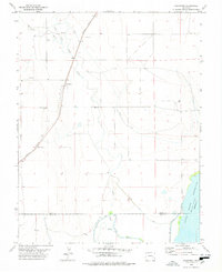
1978 Map of Arlington
USGS Topo · Published 1978About this map
Arlington sits at the junction of rail and water infrastructure in this late 1970s survey of the high plains. The settlement is positioned along the Missouri Pacific railroad line, serving as a focal point for the surrounding rural landscape. Water management is the defining characteristic of this terrain, evidenced by the extensive Colt Ditch and the Fort Lyon Storage Canal which feed into the massive Adobe Creek Reservoir (Blue Lake). These man-made features highlight the region's historical reliance on irrigation to support agriculture and ranching in a naturally arid environment.
Find a feature on this map
15 named features on this map. Tap any name to fly to it.
Don’t see what you’re looking for? This feature index may not catch every label — zoom into the map to look around manually.
Map Details
Editions of this 1978 Arlington Map
This is the sole edition of this map. No revisions or reprints were ever made.
Other maps of this area

1891 · Las Animas
USGS Topo · 1:125,000

1893 · Las Animas
USGS Topo · 1:125,000

1954 · Lamar
USGS Topo · 1:250,000

1955 · Mc Intosh Ranch
USGS Topo · 1:24,000

1955 · Bishop Ranch
USGS Topo · 1:24,000
1955 · Lewis Ranch
USGS Topo · 1:24,000

1958 · Lamar
USGS Topo · 1:250,000

1974 · Haswell
USGS Topo · 1:24,000

1974 · Arlington NE
USGS Topo · 1:24,000
1978 · Long Lake
USGS Topo · 1:24,000