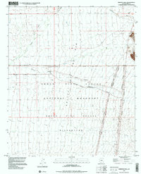
1996 Map of Armenta Well
USGS Topo · Published 2000About this map
Valley of the Ajo dominates the central portion of this survey, defining a vast desert corridor where seasonal drainages like Kuakatch Wash and Gunsight Wash carve through the arid floor. The landscape is largely protected by the Organ Pipe Cactus National Monument, which is further divided by the Organ Pipe Cactus Wilderness boundary. Human presence is sparse and concentrated at isolated points of water and work, such as Armenta Ranch and the nearby Armenta Well. These sites, along with a solitary Drill Hole and primitive 4wd tracks, reflect a hardscrabble history of ranching and resource exploration in the Pima County backcountry. To the north and east, the terrain rises toward Gunsight and the winding course of Cuerda de Leña, illustrating the remote character of the Sonoran desert during the late twentieth century.
Find a feature on this map
16 named features on this map. Tap any name to fly to it.
Don’t see what you’re looking for? This feature index may not catch every label — zoom into the map to look around manually.
Map Details
Editions of this 1996 Armenta Well Map
This is the sole edition of this map. No revisions or reprints were ever made.
Other maps of this area

1932 · Ajo
USGS Topo · 1:62,500

1934 · Ajo
USGS Topo · 1:62,500

1953 · Ajo
USGS Topo · 1:250,000

1957 · Ajo
USGS Topo · 1:250,000

1958 · Ajo
USGS Topo · 1:250,000

1962 · Ajo
USGS Topo · 1:250,000

1963 · Ajo
USGS Topo · 1:250,000

1963 · Ajo
USGS Topo · 1:62,500

1963 · Sikort Chuapo Mts
USGS Topo · 1:62,500

1963 · Mt. Ajo
USGS Topo · 1:62,500