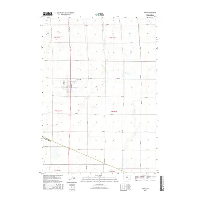
2015 Map of Armour
USGS Topo · Published 2015About this map
The town of Armour serves as the focal point of this Douglas County landscape, oriented along a rigid grid of numbered streets and named avenues. The residential and commercial layout is anchored by Main St, while local history is preserved at the Pleasant Ridge Cem on the northern edge of the settlement. The surrounding terrain is characterized by the agricultural sections typical of the Great Plains, defined by a network of section-line roads such as 391st Ave and 280th St. To the east, the meandering course of Choteau Cr provides a natural break in the geometric regularity of the prairie, while the southern border of the survey reaches the line between Douglas Co and Charles Mix Co. The inclusion of Depot St points to the area's historical reliance on transportation infrastructure to support the surrounding farming community.
Find a feature on this map
39 named features on this map. Tap any name to fly to it.
Don’t see what you’re looking for? This feature index may not catch every label — zoom into the map to look around manually.
Map Details
Editions of this 2015 Armour Map
This is the sole edition of this map. No revisions or reprints were ever made.
Other maps of this area

1955 · Mitchell
USGS Topo · 1:250,000

1959 · Mitchell
USGS Topo · 1:250,000

1964 · Wagner NE
USGS Topo · 1:24,000

1964 · Ravinia
USGS Topo · 1:24,000
1977 · Wagner NE
USGS Topo · 1:24,000
1978 · Greenwood Colony
USGS Topo · 1:24,000

1979 · Delmont
USGS Topo · 1:24,000
1979 · Armour
USGS Topo · 1:24,000
1979 · Armour SW
USGS Topo · 1:24,000
1979 · Hillside
USGS Topo · 1:24,000