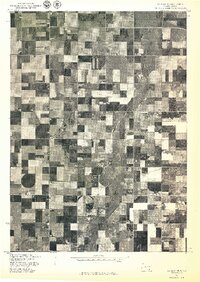
1977 Map of Wagner NE
USGS Topo · Published 1977About this map
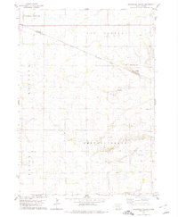
Choteau Creek meanders through a landscape defined by intensive agricultural patterns in this 1977 orthophotoquad. Produced in cooperation with the Bureau of Indian Affairs, the imagery captures the precise organization of farmsteads and fields across Charles Mix County. The high-contrast aerial photography reveals a mosaic of rectangular plots, circular center-pivot irrigation systems, and the distinct drainage path of the creek, which serves as a natural contrast to the geometric human-made divisions of the land. This visual record is particularly valuable for documenting land use and rural infrastructure in South Dakota during the late 1970s, showing the specific layout of roads and agricultural improvements that shaped the region's economy.
Find a feature on this map
1 named feature on this map. Tap any name to fly to it.
Don’t see what you’re looking for? This feature index may not catch every label — zoom into the map to look around manually.
Map Details
Editions of this 1977 Wagner NE Map
This is the sole edition of this map. No revisions or reprints were ever made.
Other maps of this area

1955 · Mitchell
USGS Topo · 1:250,000

1959 · Mitchell
USGS Topo · 1:250,000

1964 · Wagner NE
USGS Topo · 1:24,000

1964 · Ravinia
USGS Topo · 1:24,000

1964 · Wagner
USGS Topo · 1:24,000

1964 · Wagner SW
USGS Topo · 1:24,000
1972 · Dante
USGS Topo · 1:24,000
1977 · Wagner
USGS Topo · 1:24,000
1977 · Wagner SW
USGS Topo · 1:24,000
1978 · Greenwood Colony
USGS Topo · 1:24,000
Featured Places
- Independence Township, SD
- Howard Township, SD
- Kennedy Township, SD
- Plain Center Township, SD
- Bryan Township, SD