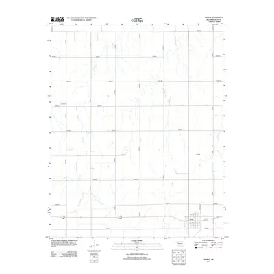
2012 Map of Arnett
USGS Topo · Published 2012About this map
The town of Arnett serves as the focal point of this Ellis County landscape, situated at the junction of several regional thoroughfares including Frantz Ave and Lincoln St. The surrounding high plains are defined by a rhythmic grid of rural routes, such as N1800 Rd and E0570 Rd, which partition the land for agricultural use. Natural drainage is carved into the terrain by several seasonal watercourses, most notably Willow Cr in the northwest and Red Bluff Cr winding through the southern reaches. Local heritage is anchored by two established burial grounds: Debolt Cem on the eastern edge of the town site and the Seventh-Day Adventist Cem located several miles to the west. This 2012 survey illustrates the enduring relationship between the structured township and the vast, creek-carved prairie of Western Oklahoma.
Find a feature on this map
26 named features on this map. Tap any name to fly to it.
Don’t see what you’re looking for? This feature index may not catch every label — zoom into the map to look around manually.
Map Details
Editions of this 2012 Arnett Map
This is the sole edition of this map. No revisions or reprints were ever made.
Other maps of this area

1955 · Woodward
USGS Topo · 1:250,000

1958 · Woodward
USGS Topo · 1:250,000

1969 · Fargo SW
USGS Topo · 1:24,000

1969 · Shattuck
USGS Topo · 1:24,000

1969 · Gage
USGS Topo · 1:24,000

1970 · Arnett
USGS Topo · 1:24,000

1970 · Arnett SE
USGS Topo · 1:24,000

1970 · Harmon SW
USGS Topo · 1:24,000
1970 · Arnett SW
USGS Topo · 1:24,000

1970 · Goodwin
USGS Topo · 1:24,000