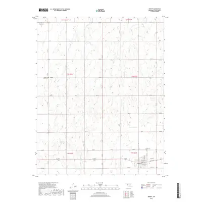
2018 Map of Arnett
USGS Topo · Published 2018About this map
Arnett stands as the primary hub of activity in this 2018 survey of Ellis County, where the street grid is detailed from Barnes Ave down to Robertson Ave. The town’s social and civic layout is clearly defined, with Lincoln St, Adams St, and Jefferson ST anchoring the residential and commercial blocks. For those looking at family history, the Debolt Cem sits on the eastern edge of town, while the Seventh-Day Adventist Cem is located further west near the banks of Willow Cr.
Find a feature on this map
41 named features on this map. Tap any name to fly to it.
Don’t see what you’re looking for? This feature index may not catch every label — zoom into the map to look around manually.
Map Details
Editions of this 2018 Arnett Map
This is the sole edition of this map. No revisions or reprints were ever made.
Other maps of this area

1955 · Woodward
USGS Topo · 1:250,000

1958 · Woodward
USGS Topo · 1:250,000

1969 · Fargo SW
USGS Topo · 1:24,000

1969 · Shattuck
USGS Topo · 1:24,000

1969 · Gage
USGS Topo · 1:24,000

1970 · Arnett
USGS Topo · 1:24,000

1970 · Arnett SE
USGS Topo · 1:24,000

1970 · Harmon SW
USGS Topo · 1:24,000
1970 · Arnett SW
USGS Topo · 1:24,000

1970 · Goodwin
USGS Topo · 1:24,000