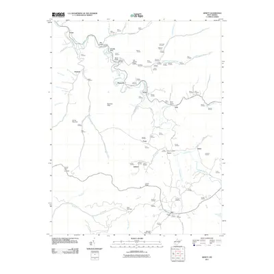
2011 Map of Arnett
USGS Topo · Published 2011About this map
Marsh Fork and Rock Creek define the geography of this Raleigh County region, where deep-seated family roots are preserved in dozens of hillside burial grounds. The map reveals a settlement pattern dictated by the winding valley floors, with small communities like Arnett, Redbird, and Saxon linked by narrow routes such as Saxon Bolt Rd and Cove Creek Rd. Genealogy researchers will find significant value in the high density of named family cemeteries, including the Pettry, Jarrell, and Scarbrough plots, which offer a clear record of the area's ancestral residents. High points such as Ivy Knob are marked by the Ivy Knob Lookout Tower, overlooking a landscape characterized by sharp ridges like Peachtree Ridge and the Skinned Poplar Gap pass. Local post offices in Dry Creek and Bolt serve as centers for these small mountain enclaves.
Find a feature on this map
106 named features on this map. Tap any name to fly to it.
Don’t see what you’re looking for? This feature index may not catch every label — zoom into the map to look around manually.
Map Details
Editions of this 2011 Arnett Map
This is the sole edition of this map. No revisions or reprints were ever made.
Other maps of this area

1891 · Oceana
USGS Topo · 1:125,000

1891 · Raleigh
USGS Topo · 1:125,000

1893 · Oceana
USGS Topo · 1:125,000

1897 · Raleigh
USGS Topo · 1:125,000

1898 · Oceana
USGS Topo · 1:125,000

1902 · Raleigh
USGS Topo · 1:125,000

1910 · Pineville
USGS Topo · 1:48,000

1910 · Bald Knob
USGS Topo · 1:48,000

1911 · Marshes
USGS Topo · 1:48,000

1912 · Mullens
USGS Topo · 1:62,500