
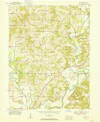
1950 Map of Arney
USGS Topo · Published 1950About this map
White River and the Eel River converge at the southern boundary of this Owen County landscape, defining a region where water and rail shaped early settlement patterns. Just north of Point Commerce, the New York Central railroad cuts through the terrain, passing near Worthington and crossing several tributaries like Corbin Creek. The map reveals a deeply established rural community identified by family-named landmarks and country churches, including Antioch Ch and Dutch Bethel Ch in the north. The presence of Farmers Ferry at the bend of the White River suggests a time when local river crossings were vital for commerce and travel between Farmers and the surrounding townships. Numerous small burial grounds, such as the Little John Cem and Oak Grove Cem, are scattered across the hills, offering specific locations for genealogical research in this 1950 survey.
Find a feature on this map
39 named features on this map. Tap any name to fly to it.
Don’t see what you’re looking for? This feature index may not catch every label — zoom into the map to look around manually.
Map Details
Editions of this 1950 Arney Map
2 editions found
Other maps of this area

1908 · Clay City
USGS Topo · 1:48,000

1908 · Bloomfield
USGS Topo · 1:62,500

1910 · Clay City
USGS Topo · 1:62,500

1938 · Coal City
USGS Topo · 1:24,000

1938 · Switz City
USGS Topo · 1:24,000

1947 · Switz City
USGS Topo · 1:24,000

1948 · Coal City
USGS Topo · 1:24,000

1950 · Switz City
USGS Topo · 1:24,000

1951 · Bloomfield
USGS Topo · 1:24,000
1953 · Coal City
USGS Topo · 1:24,000