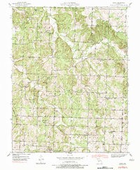
1939 Map of Arnica
USGS Topo · Published 1983About this map
Turkey Creek and its many tributaries, including South Fork Turkey Creek, carve a complex network through this section of the Ozark Plateau. The 1939 survey reveals a landscape of dispersed agricultural communities and small crossroads settlements like Arnica, Birdsong, and Claud. The area's social fabric is clearly defined by its educational and religious institutions, such as Hickory Grove Ch and a high density of rural schools, including Veercamp Sch, Shady Hill Sch, and Harvard Sch.
Find a feature on this map
31 named features on this map. Tap any name to fly to it.
Don’t see what you’re looking for? This feature index may not catch every label — zoom into the map to look around manually.
Map Details
Editions of this 1939 Arnica Map
2 editions found
Other maps of this area

1886 · Stockton
USGS Topo · 1:125,000

1938 · Roscoe
USGS Topo · 1:24,000

1938 · Vista
USGS Topo · 1:24,000

1939 · Caplinger Mills
USGS Topo · 1:24,000

1939 · Arnica
USGS Topo · 1:24,000

1940 · Roscoe
USGS Topo · 1:24,000

1940 · Vista
USGS Topo · 1:24,000

1940 · Weaubleau
USGS Topo · 1:24,000

1941 · Caplinger Mills
USGS Topo · 1:24,000

1941 · Arnica
USGS Topo · 1:24,000