
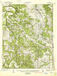
1940 Map of Vista
USGS Topo · Published 1940About this map
Sac River winds through the northwestern corner of this St. Clair County landscape, framed by the elevation of Shryers Bluff and the drainage of Coon Creek. In the years leading up to 1940, the area maintained a dense network of rural infrastructure, visible in the numerous country schools and churches that served the townships of Doyal, Washington, and Collins. The St Louis-San Francisco railroad cuts a diagonal path through the northeast, passing through the settlements of Vista and Tracy. Genealogists will find a wealth of specific landmarks, from Tower Grove Sch and Ashworth Sch to several family-named burial grounds like Doyal Cem and Culbertson Cem. The map illustrates a Missouri landscape before significant modern consolidation, where local life was still centered around small school districts and neighborhood churches like Valley Ch.
Find a feature on this map
41 named features on this map. Tap any name to fly to it.
Don’t see what you’re looking for? This feature index may not catch every label — zoom into the map to look around manually.
Map Details
Editions of this 1940 Vista Map
2 editions found
Other maps of this area

1886 · Stockton
USGS Topo · 1:125,000

1887 · Clinton
USGS Topo · 1:125,000

1894 · Clinton
USGS Topo · 1:125,000

1938 · Monegaw Springs
USGS Topo · 1:24,000

1938 · Roscoe
USGS Topo · 1:24,000

1938 · Vista
USGS Topo · 1:24,000

1939 · Caplinger Mills
USGS Topo · 1:24,000

1939 · Osceola
USGS Topo · 1:24,000

1939 · Arnica
USGS Topo · 1:24,000

1940 · Roscoe
USGS Topo · 1:24,000