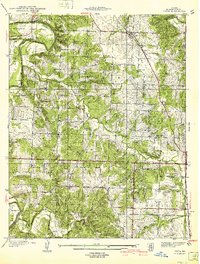
1940 Map of Vista
USGS Topo · Published 1940About this map
Coon Creek and the Sac River carve through the townships of Doyal and Washington in this 1938 survey of St. Clair County. The landscape is defined by a dense network of rural infrastructure, where small schoolhouses like Ashworth Sch and Tower Grove Sch served dispersed farming communities. Transport and trade were anchored by the St Louis-San Francisco railroad, which passes through the village of Vista and the smaller station at Tracy.
Find a feature on this map
41 named features on this map. Tap any name to fly to it.
Don’t see what you’re looking for? This feature index may not catch every label — zoom into the map to look around manually.
Map Details
Editions of this 1940 Vista Map
2 editions found

Other maps of this area

1886 · Stockton
USGS Topo · 1:125,000

1887 · Clinton
USGS Topo · 1:125,000

1894 · Clinton
USGS Topo · 1:125,000

1938 · Monegaw Springs
USGS Topo · 1:24,000

1938 · Roscoe
USGS Topo · 1:24,000

1938 · Vista
USGS Topo · 1:24,000

1939 · Caplinger Mills
USGS Topo · 1:24,000

1939 · Osceola
USGS Topo · 1:24,000

1939 · Arnica
USGS Topo · 1:24,000

1940 · Roscoe
USGS Topo · 1:24,000