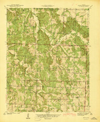
1941 Map of Arnica
USGS Topo · Published 1941About this map
Arnica and its surrounding townships in Cedar Co represent a landscape defined by small-scale agrarian settlement on the eve of World War II. The drainage patterns of Turkey Creek and Brush Creek dictate the placement of local infrastructure, where rural life centered on a dense network of country schools and churches. Notable community hubs like Williams Store and Birdsong served these isolated farmsteads, while the map preserves the exact locations of several local schools, including Liberty Sch and Prairie Mound Sch, many of which were the social anchors of their respective districts.
Find a feature on this map
32 named features on this map. Tap any name to fly to it.
Don’t see what you’re looking for? This feature index may not catch every label — zoom into the map to look around manually.
Map Details
Editions of this 1941 Arnica Map
2 editions found
Other maps of this area

1886 · Stockton
USGS Topo · 1:125,000

1938 · Roscoe
USGS Topo · 1:24,000

1938 · Vista
USGS Topo · 1:24,000

1939 · Caplinger Mills
USGS Topo · 1:24,000

1939 · Arnica
USGS Topo · 1:24,000

1940 · Roscoe
USGS Topo · 1:24,000

1940 · Vista
USGS Topo · 1:24,000

1940 · Weaubleau
USGS Topo · 1:24,000

1941 · Caplinger Mills
USGS Topo · 1:24,000

1941 · Arnica
USGS Topo · 1:24,000