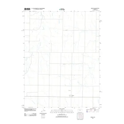
2012 Map of Arnold
USGS Topo · Published 2012About this map
Arnold stands as the primary settlement in this Western Kansas landscape, situated near the intersection of 1st St and the local highway. The map reveals a rural community supported by a network of drainage systems, including the meandering Wild Horse Cr and Rattlesnake Cr. For those researching local heritage, the presence of the Amish Cem north of town and the Arnold Cem to the south provides specific points of interest for genealogical study. The terrain is defined by its watercourses, such as Sand Cr and the N Fork Forrester Cr, which carve through the plains. The structured road grid, represented by routes like Co RD-478 and Co RD-523, illustrates the persistent township-and-range organization that governs this agricultural region.
Find a feature on this map
11 named features on this map. Tap any name to fly to it.
Don’t see what you’re looking for? This feature index may not catch every label — zoom into the map to look around manually.
Map Details
Editions of this 2012 Arnold Map
This is the sole edition of this map. No revisions or reprints were ever made.
Other maps of this area

1893 · Ellis
USGS Topo · 1:125,000

1955 · Great Bend
USGS Topo · 1:250,000

1955 · Scott City
USGS Topo · 1:250,000

1957 · Great Bend
USGS Topo · 1:250,000

1958 · Great Bend
USGS Topo · 1:250,000

1958 · Scott City
USGS Topo · 1:250,000

1965 · Utica SW
USGS Topo · 1:24,000
1966 · Ransom SW
USGS Topo · 1:24,000

1966 · Utica SE
USGS Topo · 1:24,000

1974 · Castle Rock
USGS Topo · 1:24,000