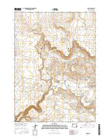
2017 Map of Arock
USGS Topo · Published 2017About this map
The settlement of Arock sits at the heart of this high-desert landscape in Malheur County, where the managed waters of Jordan Creek sustain local ranching operations. The infrastructure of the early 21st century is defined by an extensive network of reservoirs, including Dog Lake Reservoir, Merrill Reservoir, and the uniquely named No Catchum Reservoir. These water sources, connected by the N Side Canal and S Side Canal, represent the vital irrigation system necessary for survival in this arid corner of southeastern Oregon.
Find a feature on this map
34 named features on this map. Tap any name to fly to it.
Don’t see what you’re looking for? This feature index may not catch every label — zoom into the map to look around manually.
Map Details
Editions of this 2017 Arock Map
This is the sole edition of this map. No revisions or reprints were ever made.
Other maps of this area

1955 · Jordan Valley
USGS Topo · 1:250,000

1955 · Boise
USGS Topo · 1:250,000

1957 · Jordan Valley
USGS Topo · 1:250,000

1958 · Boise
USGS Topo · 1:250,000

1958 · Jordan Valley
USGS Topo · 1:250,000

1962 · Boise
USGS Topo · 1:250,000

1969 · Jordan Craters South
USGS Topo · 1:24,000
1969 · Threemile Hill
USGS Topo · 1:24,000
1969 · Dry Creek Rim
USGS Topo · 1:24,000

1972 · Owyhee Butte
USGS Topo · 1:24,000