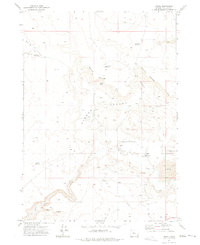
1972 Map of Arock
USGS Topo · Published 1975About this map
Jordan Creek and Dry Creek dominate this high-desert landscape in southeastern Malheur County, where the small community of Arock sits near the local Jones Sch. The terrain is defined by dramatic volcanic and erosional features, including the Hidden Valley framed by a distinct Rim and the rugged basalt flows of the Lava field to the east. Water management is the central theme of this 1972 environment, evidenced by the North Side Canal and South Side Canal drawing from the creek systems to support local agriculture.
Find a feature on this map
25 named features on this map. Tap any name to fly to it.
Don’t see what you’re looking for? This feature index may not catch every label — zoom into the map to look around manually.
Map Details
Editions of this 1972 Arock Map
This is the sole edition of this map. No revisions or reprints were ever made.
Other maps of this area

1955 · Jordan Valley
USGS Topo · 1:250,000

1955 · Boise
USGS Topo · 1:250,000

1957 · Jordan Valley
USGS Topo · 1:250,000

1958 · Boise
USGS Topo · 1:250,000

1958 · Jordan Valley
USGS Topo · 1:250,000

1962 · Boise
USGS Topo · 1:250,000

1969 · Jordan Craters South
USGS Topo · 1:24,000
1969 · Threemile Hill
USGS Topo · 1:24,000
1969 · Dry Creek Rim
USGS Topo · 1:24,000

1972 · Owyhee Butte
USGS Topo · 1:24,000