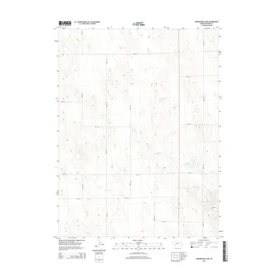
2014 Map of Arrowhead Lake
USGS Topo · Published 2014About this map
Arrow Head Lake sits as a focal point in this section of Dundy County, where the High Plains landscape is defined by the ephemeral drainage of Indian Cr. The land is partitioned by a strict grid of section-line roads, such as Road 718 and Avenue 339, reflecting the methodical agricultural survey of western Nebraska. While much of the terrain is dedicated to open range or cultivation, the presence of Oil Drilling Rd in the southeastern corner points to the region's history of natural resource extraction. This 2014 survey documents a sparsely populated but active landscape where infrastructure like Road 713 and Road 715 facilitates movement across the rolling contours and dry creek beds of the Great Plains.
Find a feature on this map
15 named features on this map. Tap any name to fly to it.
Don’t see what you’re looking for? This feature index may not catch every label — zoom into the map to look around manually.
Map Details
Editions of this 2014 Arrowhead Lake Map
This is the sole edition of this map. No revisions or reprints were ever made.
Other maps of this area

1954 · McCook
USGS Topo · 1:250,000

1957 · McCook
USGS Topo · 1:250,000

1958 · McCook
USGS Topo · 1:250,000
1961 · Parks
USGS Topo · 1:24,000

1961 · Benkelman
USGS Topo · 1:24,000
1962 · Max
USGS Topo · 1:24,000

1973 · Champion SW
USGS Topo · 1:24,000

1973 · Ough
USGS Topo · 1:24,000

1973 · Wauneta SW
USGS Topo · 1:24,000
1973 · Benkelman NW
USGS Topo · 1:24,000