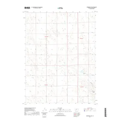
2017 Map of Arrowhead Lake
USGS Topo · Published 2017About this map
Indian Cr winds through the southwestern corner of Dundy County, feeding into the small reservoirs of Arrowhead Lake and Arrow Head Lake. This 2017 topographic survey reveals a landscape of high plains cattle country and energy exploration, defined more by its section-line roads and drainage patterns than by any urban centers. The presence of Oil Drilling Rd in the southeastern quadrant underscores the industrial utility of this terrain, while Cheyenne Canyon provides a distinct topographic break in the otherwise steady rise of the land. This map offers a clear view of the modern rural infrastructure in western Nebraska, where long thoroughfares like Ave 335 and Rd 718 connect isolated ranching and drilling interests across the Republican River basin foothills.
Find a feature on this map
23 named features on this map. Tap any name to fly to it.
Don’t see what you’re looking for? This feature index may not catch every label — zoom into the map to look around manually.
Map Details
Editions of this 2017 Arrowhead Lake Map
This is the sole edition of this map. No revisions or reprints were ever made.
Other maps of this area

1954 · McCook
USGS Topo · 1:250,000

1957 · McCook
USGS Topo · 1:250,000

1958 · McCook
USGS Topo · 1:250,000
1961 · Parks
USGS Topo · 1:24,000

1961 · Benkelman
USGS Topo · 1:24,000
1962 · Max
USGS Topo · 1:24,000

1973 · Champion SW
USGS Topo · 1:24,000

1973 · Ough
USGS Topo · 1:24,000

1973 · Wauneta SW
USGS Topo · 1:24,000
1973 · Benkelman NW
USGS Topo · 1:24,000