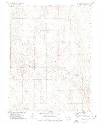
1973 Map of Arrowhead Lake
USGS Topo · Published 1977About this map
Indian Creek meanders through the eastern plains of Dundy County, feeding into the small reservoir of Arrowhead Lake. This 1973 survey illustrates a landscape defined by its water resources and utility, marked by numerous wells scattered across the undulating terrain. The tiny settlement of Southwick sits in the southwestern portion of the map, while a prominent underground Pipeline cuts diagonally across the center, linking the region's infrastructure. To the southeast, a Gravel Pit and the flow of Spring Creek highlight the localized extractive and hydrological patterns of the era. The mapping provides a clear record of the section lines and township boundaries, specifically T 3 N and T 2 N, which organized the agricultural and pastoral life of the High Plains during the mid-1970s.
Find a feature on this map
9 named features on this map. Tap any name to fly to it.
Don’t see what you’re looking for? This feature index may not catch every label — zoom into the map to look around manually.
Map Details
Editions of this 1973 Arrowhead Lake Map
This is the sole edition of this map. No revisions or reprints were ever made.
Other maps of this area

1954 · McCook
USGS Topo · 1:250,000

1957 · McCook
USGS Topo · 1:250,000

1958 · McCook
USGS Topo · 1:250,000
1961 · Parks
USGS Topo · 1:24,000

1961 · Benkelman
USGS Topo · 1:24,000
1962 · Max
USGS Topo · 1:24,000

1973 · Champion SW
USGS Topo · 1:24,000

1973 · Ough
USGS Topo · 1:24,000

1973 · Wauneta SW
USGS Topo · 1:24,000
1973 · Benkelman NW
USGS Topo · 1:24,000