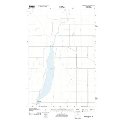
2011 Map of Arrowwood Lake
USGS Topo · Published 2011About this map
Arrowwood Lake dominates this central North Dakota landscape, where the James River expands through a significant valley. This 2011 survey illustrates the managed water systems of Stutsman County, centered on the Arrowwood Dam at the southern end of the lake. The terrain is characterized by prairie drainage features such as Bennetts Coulee and Stony Brook, which feed into the river system. North of the main water body, Dry Lake sits within a network of section-line roads like Hart Bridge Rd and 3rd St SE. The map reflects the organized grid of the Great Plains, where high-numbered avenues and streets facilitate movement through a sparsely populated agricultural and conservation-focused region.
Find a feature on this map
23 named features on this map. Tap any name to fly to it.
Don’t see what you’re looking for? This feature index may not catch every label — zoom into the map to look around manually.
Map Details
Editions of this 2011 Arrowwood Lake Map
This is the sole edition of this map. No revisions or reprints were ever made.
Other maps of this area

1900 · Pingree
USGS Topo · 1:125,000

1900 · Pingree
USGS Topo · 1:62,500

1951 · Bordulac NE
USGS Topo · 1:24,000

1951 · Arrowwood Lake
USGS Topo · 1:24,000

1951 · Kensal
USGS Topo · 1:24,000

1951 · Kensal NW
USGS Topo · 1:24,000

1951 · Pingree
USGS Topo · 1:24,000

1951 · Bordulac SW
USGS Topo · 1:24,000
1951 · Bordulac
USGS Topo · 1:24,000

1952 · Jim Lake
USGS Topo · 1:24,000