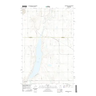
2014 Map of Arrowwood Lake
USGS Topo · Published 2014About this map
Arrowwood Lake dominates the center of this landscape along the border of Foster and Stutsman Counties. Fed by the James River from the north and Stony Brook from the southeast, the lake sits within a distinct glacial depression characterized by the Bennetts Coulee landform. The map documents a blend of early transportation history and modern infrastructure, featuring the historic path of the Fort Totten Trail crossing the southern portion of the sheet. Modern recreation is represented by the Warbler Woodland Trail, while the local section line road network, including Hart Bridge Rd and ND-9, provides a clear view of the rural township organization that has defined this North Dakota prairie region since settlement.
Find a feature on this map
30 named features on this map. Tap any name to fly to it.
Don’t see what you’re looking for? This feature index may not catch every label — zoom into the map to look around manually.
Map Details
Editions of this 2014 Arrowwood Lake Map
This is the sole edition of this map. No revisions or reprints were ever made.
Other maps of this area

1900 · Pingree
USGS Topo · 1:125,000

1900 · Pingree
USGS Topo · 1:62,500

1951 · Bordulac NE
USGS Topo · 1:24,000

1951 · Arrowwood Lake
USGS Topo · 1:24,000

1951 · Kensal
USGS Topo · 1:24,000

1951 · Kensal NW
USGS Topo · 1:24,000

1951 · Pingree
USGS Topo · 1:24,000

1951 · Bordulac SW
USGS Topo · 1:24,000
1951 · Bordulac
USGS Topo · 1:24,000

1952 · Jim Lake
USGS Topo · 1:24,000