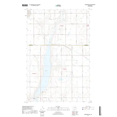
2017 Map of Arrowwood Lake
USGS Topo · Published 2017About this map
Arrowwood Lake dominates this northern prairie landscape, shaped by the passage of the James River through the heart of Stutsman and Foster counties. The map traces the historical path of the Fort Totten Trail as it skirts the western shore of the lake, a route that once connected frontier outposts across the Dakota Territory. This modern topographic study reveals a rugged hydrology characterized by seasonal wetlands and tributary systems including Dollar Slough, Stony Brook, and the distinct relief of Bennetts Coulee. While the section lines of the Public Land Survey System define the modern property boundaries, the enduring presence of the trail and named crossings like Hart Bridge Rd mark the transition from early migration routes to the established agricultural grid of the present day.
Find a feature on this map
21 named features on this map. Tap any name to fly to it.
Don’t see what you’re looking for? This feature index may not catch every label — zoom into the map to look around manually.
Map Details
Editions of this 2017 Arrowwood Lake Map
This is the sole edition of this map. No revisions or reprints were ever made.
Other maps of this area

1900 · Pingree
USGS Topo · 1:125,000

1900 · Pingree
USGS Topo · 1:62,500

1951 · Bordulac NE
USGS Topo · 1:24,000

1951 · Arrowwood Lake
USGS Topo · 1:24,000

1951 · Kensal
USGS Topo · 1:24,000

1951 · Kensal NW
USGS Topo · 1:24,000

1951 · Pingree
USGS Topo · 1:24,000

1951 · Bordulac SW
USGS Topo · 1:24,000
1951 · Bordulac
USGS Topo · 1:24,000

1952 · Jim Lake
USGS Topo · 1:24,000