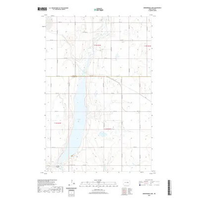
2020 Map of Arrowwood Lake
USGS Topo · Published 2020About this map
Arrowwood Lake dominates this section of the Central North Dakota plains, marking a significant widening of the James River corridor. The landscape is defined by the glacial hydrology of the region, where the river system feeds into the large lake and smaller wetlands like Dollar Slough and the winding Stony Brook. A notable piece of regional heritage is preserved here in the form of the Fort Totten Trail, which cuts across the southern portion of the quadrangle near Bennetts Coulee. This historic thoroughfare, once a vital link between frontier military outposts, remains a tangible mark on the land. The map also captures the precise boundary where Foster and Stutsman counties meet, showing a regular grid of section roads like Hart Bridge Rd that overlay the older natural and historic paths.
Find a feature on this map
22 named features on this map. Tap any name to fly to it.
Don’t see what you’re looking for? This feature index may not catch every label — zoom into the map to look around manually.
Map Details
Editions of this 2020 Arrowwood Lake Map
This is the sole edition of this map. No revisions or reprints were ever made.
Other maps of this area

1900 · Pingree
USGS Topo · 1:125,000

1900 · Pingree
USGS Topo · 1:62,500

1951 · Bordulac NE
USGS Topo · 1:24,000

1951 · Arrowwood Lake
USGS Topo · 1:24,000

1951 · Kensal
USGS Topo · 1:24,000

1951 · Kensal NW
USGS Topo · 1:24,000

1951 · Pingree
USGS Topo · 1:24,000

1951 · Bordulac SW
USGS Topo · 1:24,000
1951 · Bordulac
USGS Topo · 1:24,000

1952 · Jim Lake
USGS Topo · 1:24,000