
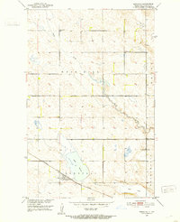
1951 Map of Arrowwood Lake
USGS Topo · Published 1951About this map
Arrowwood National Wildlife Refuge dominates this mid-century survey of the Central Flyway, centering on the expanse of Arrowwood Lake and the serpentine path of the James River. This landscape reflects the dual nature of the era's land management, balancing the preservation of wetlands with the receding traces of early prairie settlement. The map documents a transition in rural education, marking active sites like School No 1 and School No 4 alongside the structural remains of School No 2 (Abandoned) and School No 3 (Abandoned). The Minneapolis St Paul and Sault Ste Marie line bisects the northern refuge, while the Refuge Headquarters and a prominent Lookout Tower stand as administrative anchors. Smaller hydrological features such as Dollar Slough, Stony Brook, and the dry bed of Dry Lake reveal the intricate drainage patterns of the Bucephalia and Edmunds districts.
Find a feature on this map
21 named features on this map. Tap any name to fly to it.
Don’t see what you’re looking for? This feature index may not catch every label — zoom into the map to look around manually.
Map Details
Editions of this 1951 Arrowwood Lake Map
This is the sole edition of this map. No revisions or reprints were ever made.
Other maps of this area

1900 · Pingree
USGS Topo · 1:125,000

1900 · Pingree
USGS Topo · 1:62,500

1951 · Bordulac NE
USGS Topo · 1:24,000

1951 · Kensal
USGS Topo · 1:24,000

1951 · Kensal NW
USGS Topo · 1:24,000

1951 · Pingree
USGS Topo · 1:24,000

1951 · Bordulac SW
USGS Topo · 1:24,000
1951 · Bordulac
USGS Topo · 1:24,000

1952 · Jim Lake
USGS Topo · 1:24,000

1952 · Courtenay NW
USGS Topo · 1:24,000