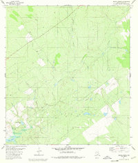
1980 Map of Arroyo Burro
USGS Topo · Published 1980About this map
Falcon Reservoir defines the southwestern edge of this landscape in Zapata County, where the rising waters of the Rio Grande reach into the brushy draws of South Texas. This 1980 survey captures a network of ephemeral drainage systems, or arroyos, that characterize the ranchland terrain. Notable among these are Arroyo Burro, Arroyo Blanco, and Cavasara Creek, which cut through the arid plains toward the reservoir. Human activity is marked by scattered infrastructure typical of the region's ranching and industrial history, including the Refugio Ramirez Tank, a local Gravel Pit, and various isolated well sites. The terrain is further distinguished by features such as Cañada Las Palomas and Arroyo Rosita, illustrating how local naming conventions have long relied on these vital, if seasonal, watercourses to navigate the South Texas brush country.
Find a feature on this map
12 named features on this map. Tap any name to fly to it.
Don’t see what you’re looking for? This feature index may not catch every label — zoom into the map to look around manually.
Map Details
Editions of this 1980 Arroyo Burro Map
This is the sole edition of this map. No revisions or reprints were ever made.
Other maps of this area

1940 · Mogotes Hill
USGS Topo · 1:62,500

1942 · San Ygnacio
USGS Topo · 1:62,500

1949 · Mc Allen
USGS Topo · 1:250,000

1954 · McAllen
USGS Topo · 1:250,000

1956 · Mogotes Hill
USGS Topo · 1:62,500

1956 · Zapata
USGS Topo · 1:62,500

1956 · Arroyo Clareno
USGS Topo · 1:62,500

1956 · Laredo
USGS Topo · 1:250,000

1957 · Mc Allen
USGS Topo · 1:250,000

1962 · McAllen
USGS Topo · 1:250,000