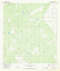
1980 Map of Arroyo Huisache
USGS Topo · Published 1980About this map
Bustamante sits at the northern edge of this Zapata County landscape, where the brush country is defined by an intricate network of seasonal drainage and water management. The terrain is marked by numerous stock tanks bearing family or local names, such as Lobitas Tank, Volpe Tank, and Adame Tank, which were essential for ranching in this arid South Texas environment. A small Cem near the settlement provides a point of interest for genealogists tracing early families in the region.
Find a feature on this map
25 named features on this map. Tap any name to fly to it.
Don’t see what you’re looking for? This feature index may not catch every label — zoom into the map to look around manually.
Map Details
Editions of this 1980 Arroyo Huisache Map
This is the sole edition of this map. No revisions or reprints were ever made.
Other maps of this area

1938 · Cuevitas
USGS Topo · 1:62,500

1939 · Randado
USGS Topo · 1:62,500

1940 · Randado
USGS Topo · 1:62,500

1940 · Mogotes Hill
USGS Topo · 1:62,500

1949 · Mc Allen
USGS Topo · 1:250,000

1954 · McAllen
USGS Topo · 1:250,000

1956 · Mogotes Hill
USGS Topo · 1:62,500

1956 · Arroyo Clareno
USGS Topo · 1:62,500

1956 · Laredo
USGS Topo · 1:250,000

1957 · Mc Allen
USGS Topo · 1:250,000