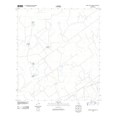
2010 Map of Arroyo Salado East
USGS Topo · Published 2010About this map
Mecom Ranch and other large-scale ranching interests define the landscape of Zapata County in the early 21st century. This region of South Texas is characterized by a series of engineered water management features, most notably a sequence of dams including Jesse McNeel Lake Number 2 Dam, Jesse McNeel Lake Number 3 Dam, and Jesse McNeel Lake Number 4 Dam. These reservoirs indicate the vital importance of water storage for cattle operations in an arid climate. The terrain is crossed by the drainage of Cavasara Creek and served by rural infrastructure such as Ranch Rd 3169. The map provides a detailed record of land use on the Mecom Ranch, showing how the land has been partitioned and modified to support ranching through the construction of numerous small stock tanks and lakes.
Find a feature on this map
8 named features on this map. Tap any name to fly to it.
Don’t see what you’re looking for? This feature index may not catch every label — zoom into the map to look around manually.
Map Details
Editions of this 2010 Arroyo Salado East Map
This is the sole edition of this map. No revisions or reprints were ever made.
Other maps of this area

1933 · Becerra Creek
USGS Topo · 1:62,500

1940 · Aguilares
USGS Topo · 1:62,500

1940 · Mogotes Hill
USGS Topo · 1:62,500

1942 · San Ygnacio
USGS Topo · 1:62,500

1956 · Mogotes Hill
USGS Topo · 1:62,500

1956 · Laredo
USGS Topo · 1:250,000
1979 · San Ygnacio
USGS Topo · 1:24,000

1979 · O'Keefe Lake
USGS Topo · 1:24,000
1980 · Mogotes Hill
USGS Topo · 1:24,000
1980 · Agua Azul Creek West
USGS Topo · 1:24,000