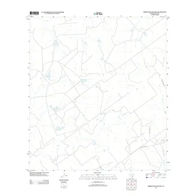
2013 Map of Arroyo Salado East
USGS Topo · Published 2013About this map
The south Texas scrublands of Zapata County are defined by their hydrological patterns and ranching infrastructure on this 2013 survey. Notable water features like Jesse McNeel Lake Number 3, Jesse McNeel Lake Number 4, and Mecom Ranch Lake indicate the importance of managed water resources in this arid environment. These reservoirs, alongside the winding Cavasara Creek, support the surrounding cattle country. The map shows a network of rural routes, including Ranch Road 3169 and family-named thoroughfares such as William McMurray Road and La Purisima Road. This landscape reflects the modern ranching era where large landholdings are connected by long-established gravel and paved access roads.
Find a feature on this map
8 named features on this map. Tap any name to fly to it.
Don’t see what you’re looking for? This feature index may not catch every label — zoom into the map to look around manually.
Map Details
Editions of this 2013 Arroyo Salado East Map
This is the sole edition of this map. No revisions or reprints were ever made.
Other maps of this area

1933 · Becerra Creek
USGS Topo · 1:62,500

1940 · Aguilares
USGS Topo · 1:62,500

1940 · Mogotes Hill
USGS Topo · 1:62,500

1942 · San Ygnacio
USGS Topo · 1:62,500

1956 · Mogotes Hill
USGS Topo · 1:62,500

1956 · Laredo
USGS Topo · 1:250,000
1979 · San Ygnacio
USGS Topo · 1:24,000

1979 · O'Keefe Lake
USGS Topo · 1:24,000
1980 · Mogotes Hill
USGS Topo · 1:24,000
1980 · Agua Azul Creek West
USGS Topo · 1:24,000