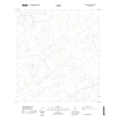
2019 Map of Arroyo Salado East
USGS Topo · Published 2019About this map
Arroyo Salado winds through this arid landscape of southern Zapata County, where water management is defined by private ranching infrastructure. The map reveals the placement of several artificial catchments, most notably Jesse McNeel Lake Number 4 and Mecom Ranch Lake, which serve as vital water sources in this brushy terrain. The sparse road network is centered on Ranch Rd 3169 (also labeled Fm 3169), which cuts through the southern portion of the quadrangle. Aside from these primary routes, the land is marked by a complex web of private ranch roads and seismic lines typical of South Texas oil and gas country. Seasonal drainages like Cavasara Cr illustrate the natural runoff patterns that dictate the location of these isolated ranching improvements.
Find a feature on this map
6 named features on this map. Tap any name to fly to it.
Don’t see what you’re looking for? This feature index may not catch every label — zoom into the map to look around manually.
Map Details
Editions of this 2019 Arroyo Salado East Map
This is the sole edition of this map. No revisions or reprints were ever made.
Other maps of this area

1933 · Becerra Creek
USGS Topo · 1:62,500

1940 · Aguilares
USGS Topo · 1:62,500

1940 · Mogotes Hill
USGS Topo · 1:62,500

1942 · San Ygnacio
USGS Topo · 1:62,500

1956 · Mogotes Hill
USGS Topo · 1:62,500

1956 · Laredo
USGS Topo · 1:250,000
1979 · San Ygnacio
USGS Topo · 1:24,000

1979 · O'Keefe Lake
USGS Topo · 1:24,000
1980 · Mogotes Hill
USGS Topo · 1:24,000
1980 · Agua Azul Creek West
USGS Topo · 1:24,000