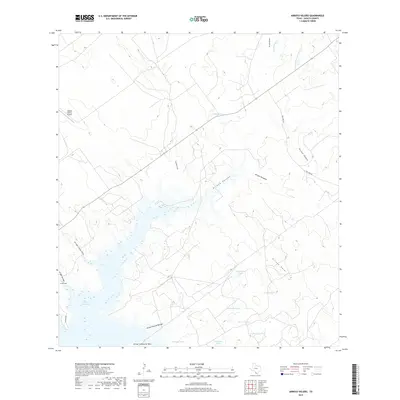
2019 Map of Arroyo Veleno
USGS Topo · Published 2019About this map
The waters of Falcon Reservoir dominate the southwestern corner of this landscape, where the inlets of Arroyo Costa Rica, Arroyo Torcido, and Arroyo Indio meet the reservoir's irregular shoreline. This South Texas terrain is defined by an intricate network of seasonal drainage channels, or arroyos, that carve through the brush country toward the Rio Grande basin. Local ranching history is evidenced by the numerous water tanks scattered across the quadrangle, including Maestro Tank, El Rancho Tank, and Charco Tank, which serve as vital water sources for livestock in this arid environment. The presence of the Zapata County Airport and the corridor of Lozano Ave indicate the modern infrastructure supporting this borderlands region. Further inland, the complex hydrology continues with features like Arroyo Veleno and Arroyo Humaran, while smaller tracks such as San Jose Rd provide access to the hinterlands between the arroyo systems.
Find a feature on this map
25 named features on this map. Tap any name to fly to it.
Don’t see what you’re looking for? This feature index may not catch every label — zoom into the map to look around manually.
Map Details
Editions of this 2019 Arroyo Veleno Map
This is the sole edition of this map. No revisions or reprints were ever made.
Other maps of this area

1940 · Mogotes Hill
USGS Topo · 1:62,500

1942 · San Ygnacio
USGS Topo · 1:62,500

1949 · Mc Allen
USGS Topo · 1:250,000

1954 · McAllen
USGS Topo · 1:250,000

1956 · Mogotes Hill
USGS Topo · 1:62,500

1956 · Zapata
USGS Topo · 1:62,500

1956 · Arroyo Clareno
USGS Topo · 1:62,500

1956 · Laredo
USGS Topo · 1:250,000

1957 · Mc Allen
USGS Topo · 1:250,000

1962 · McAllen
USGS Topo · 1:250,000