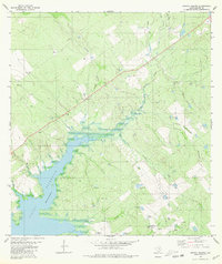
1980 Map of Arroyo Veleno
USGS Topo · Published 1980About this map
The expansive waters of Falcon Reservoir dominate the southwestern corner of this landscape, where the inundated shoreline meets a network of ephemeral drainages typical of the South Texas brush country. Inland from the reservoir, the terrain is defined by complex arroyo systems including Arroyo Veleno, Arroyo Humaran, and Arroyo Plan de Barajas. These waterways are punctuated by numerous named livestock tanks such as Ranchito Tank, El Rancho Tank, and La Esquina Tank, which serve as vital water sources in this semi-arid ranching environment.
Find a feature on this map
24 named features on this map. Tap any name to fly to it.
Don’t see what you’re looking for? This feature index may not catch every label — zoom into the map to look around manually.
Map Details
Editions of this 1980 Arroyo Veleno Map
This is the sole edition of this map. No revisions or reprints were ever made.
Other maps of this area

1940 · Mogotes Hill
USGS Topo · 1:62,500

1942 · San Ygnacio
USGS Topo · 1:62,500

1949 · Mc Allen
USGS Topo · 1:250,000

1954 · McAllen
USGS Topo · 1:250,000

1956 · Mogotes Hill
USGS Topo · 1:62,500

1956 · Zapata
USGS Topo · 1:62,500

1956 · Arroyo Clareno
USGS Topo · 1:62,500

1956 · Laredo
USGS Topo · 1:250,000

1957 · Mc Allen
USGS Topo · 1:250,000

1962 · McAllen
USGS Topo · 1:250,000