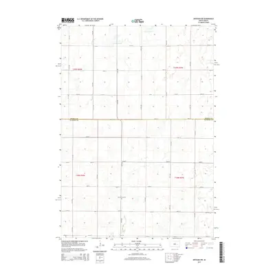
2015 Map of Artesian NW
USGS Topo · Published 2015About this map
Saint Anthonys Cem serves as a central landmark in this portion of Sanborn County, reflecting the deep-rooted community ties in South Dakota's rural heartland. The landscape is defined by the gentle drainage patterns of the S Fork Pearl Cr and Stony Run, which meander through a grid-iron network of section roads. This 2015 survey reveals a terrain shaped by the Public Land Survey System, where townships like t109n r59w and t108n r60w meet at the border of Beadle Co and Sanborn Co. The spatial organization of the land into precise mile-square sections, accessed by numbered thoroughfares such as 413th Ave and 220th St, highlights the enduring agricultural framework of the Great Plains. For researchers, the map provides a clear record of land divisions and the specific location of the cemetery as it appeared in the mid-2010s.
Find a feature on this map
24 named features on this map. Tap any name to fly to it.
Don’t see what you’re looking for? This feature index may not catch every label — zoom into the map to look around manually.
Map Details
Editions of this 2015 Artesian NW Map
This is the sole edition of this map. No revisions or reprints were ever made.
Other maps of this area

1898 · Huron
USGS Topo · 1:125,000

1899 · De Smet
USGS Topo · 1:125,000

1953 · Huron
USGS Topo · 1:250,000

1953 · Watertown
USGS Topo · 1:250,000

1954 · Huron
USGS Topo · 1:250,000

1957 · Forestburg NE
USGS Topo · 1:24,000
1957 · Forestburg
USGS Topo · 1:24,000

1957 · Cavour
USGS Topo · 1:24,000

1958 · Watertown
USGS Topo · 1:250,000

1971 · Iroquois
USGS Topo · 1:24,000