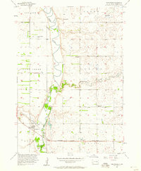
1957 Map of Forestburg
USGS Topo · Published 1958About this map
The winding James River snakes through this 1957 survey of Sanborn County, creating a fertile valley corridor bordered by the townships of Jackson, Floyd, Silver Creek, and Oneida. The settlement of Forestburg is situated south of Sand Creek, serving as a focal point along the Chicago Milwaukee St Paul and Pacific railroad line. This period shows a transition in rural education, as both Rubert Sch and Ferguson Sch are marked as abandoned, suggesting the consolidation of local school districts in mid-century South Dakota.
Find a feature on this map
19 named features on this map. Tap any name to fly to it.
Don’t see what you’re looking for? This feature index may not catch every label — zoom into the map to look around manually.
Map Details
Editions of this 1957 Forestburg Map
This is the sole edition of this map. No revisions or reprints were ever made.
Other maps of this area

1898 · Huron
USGS Topo · 1:125,000

1899 · Mitchell
USGS Topo · 1:125,000

1899 · Alexandria
USGS Topo · 1:125,000

1899 · De Smet
USGS Topo · 1:125,000

1953 · Huron
USGS Topo · 1:250,000

1953 · Watertown
USGS Topo · 1:250,000

1954 · Huron
USGS Topo · 1:250,000

1955 · Sioux Falls
USGS Topo · 1:250,000

1955 · Mitchell
USGS Topo · 1:250,000

1957 · Forestburg NE
USGS Topo · 1:24,000