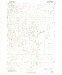
1971 Map of Artesian
USGS Topo · Published 1973About this map
Artesian serves as the focal point of this Sanborn County landscape, situated at the intersection of a grid-pattern road network and the Chicago Milwaukee St Paul and Pacific railroad. The town's layout and its proximity to the rail line reflect the essential transport infrastructure of the South Dakota prairie in the early 1970s. The surrounding geography is defined by townships such as Diana, Benedict, and Oneida, where the land is carved by the meandering courses of Redstone Creek and West Redstone Creek.
Find a feature on this map
18 named features on this map. Tap any name to fly to it.
Don’t see what you’re looking for? This feature index may not catch every label — zoom into the map to look around manually.
Map Details
Editions of this 1971 Artesian Map
This is the sole edition of this map. No revisions or reprints were ever made.
Other maps of this area

1898 · Huron
USGS Topo · 1:125,000

1899 · Mitchell
USGS Topo · 1:125,000

1899 · Alexandria
USGS Topo · 1:125,000

1899 · De Smet
USGS Topo · 1:125,000

1953 · Huron
USGS Topo · 1:250,000

1953 · Watertown
USGS Topo · 1:250,000

1954 · Huron
USGS Topo · 1:250,000

1955 · Sioux Falls
USGS Topo · 1:250,000

1955 · Mitchell
USGS Topo · 1:250,000

1957 · Forestburg NE
USGS Topo · 1:24,000