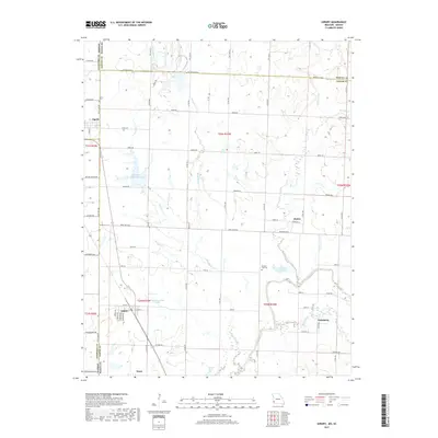
2017 Map of Asbury
USGS Topo · Published 2017About this map
The town of Asbury sits near the Kansas-Missouri state line, serving as a hub for the surrounding agricultural and rural landscape of Jasper County. This 2017 survey shows a region defined by its water resources, with the North Fork Spring River and Spring River winding through the eastern portion of the quadrangle. Significant water bodies like Blackberry Hay Farm Lake, Asbury Farms Lake, and Browning West Lake suggest a landscape heavily managed for irrigation and local industry. Smaller settlements like Medoc, Galesburg, and Waco are connected by a grid of named rural roads, including Base Line Blvd and Sumac Rd. Genealogists will find the locations of Davis Cem and Georgia City Cem particularly useful for tracing family roots in this border region, while the proximity of Opolis on the state line highlights the historical movement of people and goods between Crawford County, Kansas, and Jasper County, Missouri.
Find a feature on this map
53 named features on this map. Tap any name to fly to it.
Don’t see what you’re looking for? This feature index may not catch every label — zoom into the map to look around manually.
Map Details
Editions of this 2017 Asbury Map
This is the sole edition of this map. No revisions or reprints were ever made.
Other maps of this area

1886 · Joplin
USGS Topo · 1:125,000

1886 · Carthage
USGS Topo · 1:125,000

1894 · Joplin
USGS Topo · 1:125,000

1894 · Carthage
USGS Topo · 1:125,000

1945 · Pittsburg
USGS Topo · 1:62,500

1947 · Joplin
USGS Topo · 1:250,000

1947 · Pittsburg
USGS Topo · 1:62,500

1949 · Joplin
USGS Topo · 1:250,000

1950 · Pittsburg
USGS Topo · 1:62,500

1954 · Joplin
USGS Topo · 1:250,000