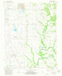
1981 Map of Asbury
USGS Topo · Published 1981About this map
Asbury stands at a significant transportation junction in Jasper County, where the Kansas City Southern railway intersects an Old Railroad Grade near the state line. The landscape is a transition between the prairie and river systems, featuring the Wah-Sha-She Prairie State Wildlife Area and the confluence of the North Fork and Spring River. Local industry is visible in the north via a prominent Strip Mine and scattered gravel pits near Galesburg. Smaller settlements like Opolis, Medoc, and Waco dot the region, connected by a network of creeks including Blackberry Creek and Pond Creek. Genealogical interest is found at the Georgia City Cem and various family-named landmarks such as the Blackberry Hay Farm Lake, providing a clear record of the area's rural development and land use toward the end of the 20th century.
Find a feature on this map
31 named features on this map. Tap any name to fly to it.
Don’t see what you’re looking for? This feature index may not catch every label — zoom into the map to look around manually.
Map Details
Editions of this 1981 Asbury Map
This is the sole edition of this map. No revisions or reprints were ever made.
Other maps of this area

1886 · Joplin
USGS Topo · 1:125,000

1886 · Carthage
USGS Topo · 1:125,000

1894 · Joplin
USGS Topo · 1:125,000

1894 · Carthage
USGS Topo · 1:125,000

1945 · Pittsburg
USGS Topo · 1:62,500

1947 · Joplin
USGS Topo · 1:250,000

1947 · Pittsburg
USGS Topo · 1:62,500

1949 · Joplin
USGS Topo · 1:250,000

1950 · Pittsburg
USGS Topo · 1:62,500

1954 · Joplin
USGS Topo · 1:250,000