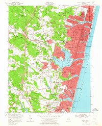
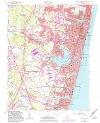
1954 Map of Asbury Park
USGS Topo · Published 1964About this map
Asbury Park and its neighboring Shore communities anchor this mid-century topographic survey, showing the density of coastal development from Allenhurst south to Sea Girt. The era’s landscape is defined by the recently constructed Garden State Parkway cutting through the western farmlands, contrasted with the established beach resorts and their landmarks like the Convention Hall and Auditorium. The map reveals the intricate water network of the Shark River and its various ponds, such as Silver Lake and Lake Como, which shaped the early residential layouts of Belmar and Avon-by-the-Sea.
Find a feature on this map
168 named features on this map. Tap any name to fly to it.
Don’t see what you’re looking for? This feature index may not catch every label — zoom into the map to look around manually.
Map Details
Editions of this 1954 Asbury Park Map
5 editions found
Other maps of this area

1888 · Asbury Park
USGS Topo · 1:62,500

1888 · Sandy Hook
USGS Topo · 1:62,500

1893 · Sandy Hook
USGS Topo · 1:62,500

1893 · Asbury Park
USGS Topo · 1:62,500

1901 · Sandy Hook
USGS Topo · 1:62,500

1901 · Asbury Park
USGS Topo · 1:62,500

1902 · Navesink
USGS Topo · 1:125,000

1918 · Sandy Hook
USGS Topo · 1:62,500

1919 · Asbury Park
USGS Topo · 1:62,500

1942 · Farmingdale
USGS Topo · 1:24,000