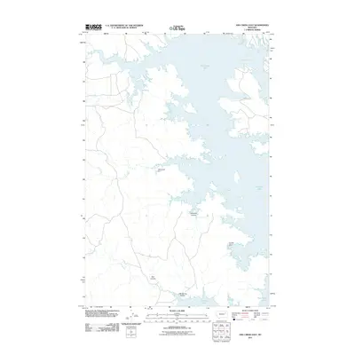
2011 Map of Ash Creek East
USGS Topo · Published 2011About this map
Fort Peck Lake dominates this portion of McCone County, creating a sprawling shoreline where the water meets the distinct drainage patterns of the Missouri River country. The landscape is defined by its coulees and basins, including the prominent Jawbone Coulee and Coyote Basin, which channel seasonal runoff toward the lake's eastern reaches. This modern survey reflects the geography of the early 21st century, illustrating how infrastructure like Road 217 and the CM Russell Dam integrate with the natural hydrology of Ash Creek and Rock Creek Bay. Historically significant watercourses such as Lost Creek and the forks of Box Creek, specifically N Fk Box Cr and S Fk Box Cr, continue to shape the terrain as they have for generations. Local features like Bell Coulee and CBC Spring Coulee provide precise points of reference for those studying the specific landforms of this prairie environment.
Find a feature on this map
12 named features on this map. Tap any name to fly to it.
Don’t see what you’re looking for? This feature index may not catch every label — zoom into the map to look around manually.
Map Details
Editions of this 2011 Ash Creek East Map
This is the sole edition of this map. No revisions or reprints were ever made.
Other maps of this area

1954 · Jordan
USGS Topo · 1:250,000

1956 · Jordan
USGS Topo · 1:250,000

1958 · Jordan
USGS Topo · 1:250,000

1964 · Jordan
USGS Topo · 1:250,000

1972 · Short Creek
USGS Topo · 1:24,000

1972 · Flat Creek School
USGS Topo · 1:24,000
1972 · Spring Creek Bay
USGS Topo · 1:24,000
1972 · Norville Creek
USGS Topo · 1:24,000

1972 · Ash Creek East
USGS Topo · 1:24,000
1972 · Ash Creek West
USGS Topo · 1:24,000