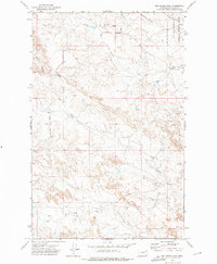
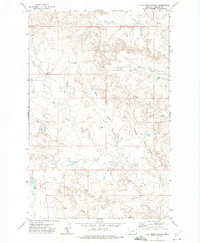
1972 Map of Ash Creek West
USGS Topo · Published 1975About this map
The Charles M Russell National Wildlife Range dominates the northeastern corner of this Garfield County landscape, illustrating the region's dedicated conservation efforts during the early 1970s. This sparsely populated area of Montana is defined by its drainage systems, including the South Fork Box Creek and the meandering Ash Creek. A solitary center of local activity is represented by the Cat Creek Sch, located along Haxby Road. The presence of a Landing Strip and named terrain features like Coal Bank Hill and Petrick Coulee suggest a working landscape of ranching and light transport. The map's network of intermittent streams, such as Lost Creek and Lone Tree Creek, reveals a rugged prairie environment where water access and topographic navigation were essential for local residents and land managers alike.
Find a feature on this map
12 named features on this map. Tap any name to fly to it.
Don’t see what you’re looking for? This feature index may not catch every label — zoom into the map to look around manually.
Map Details
Editions of this 1972 Ash Creek West Map
This is the sole edition of this map. No revisions or reprints were ever made.
Other maps of this area

1954 · Jordan
USGS Topo · 1:250,000

1956 · Jordan
USGS Topo · 1:250,000

1958 · Jordan
USGS Topo · 1:250,000
1958 · Sage Creek Point
USGS Topo · 1:24,000

1964 · Jordan
USGS Topo · 1:250,000
1972 · Short Creek
USGS Topo · 1:24,000
1972 · Gilbert Creek SE
USGS Topo · 1:24,000
1972 · Flat Creek School
USGS Topo · 1:24,000
1972 · Spring Creek Bay
USGS Topo · 1:24,000
1972 · Gilbert Creek
USGS Topo · 1:24,000