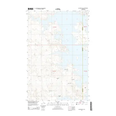
2014 Map of Ash Creek East
USGS Topo · Published 2014About this map
Fort Peek Lake and its intricate shoreline dominate this northeastern Montana landscape, where the waters of the Missouri River reservoir extend into the rugged breaks of McCone and Garfield counties. The topography is defined by complex drainage systems that feed into the lake, including the winding paths of Lost Cr, Ash Cr, and Cat Cr. These watercourses have carved out significant features like Jawbone Coulee and Bell Coulee, creating a dissected terrain of ridges and basins. Along the eastern reaches of the lake, Daniels Point stands as a prominent landmark overlooking Coyote Basin. This 2014 survey captures the interface between the massive reservoir and the high plains, showing a sparse road network consisting of Road 899 and Road 531 that navigate the challenging contours of the Big Dry country.
Find a feature on this map
19 named features on this map. Tap any name to fly to it.
Don’t see what you’re looking for? This feature index may not catch every label — zoom into the map to look around manually.
Map Details
Editions of this 2014 Ash Creek East Map
This is the sole edition of this map. No revisions or reprints were ever made.
Other maps of this area

1954 · Jordan
USGS Topo · 1:250,000

1956 · Jordan
USGS Topo · 1:250,000

1958 · Jordan
USGS Topo · 1:250,000

1964 · Jordan
USGS Topo · 1:250,000

1972 · Short Creek
USGS Topo · 1:24,000

1972 · Flat Creek School
USGS Topo · 1:24,000
1972 · Spring Creek Bay
USGS Topo · 1:24,000
1972 · Norville Creek
USGS Topo · 1:24,000

1972 · Ash Creek East
USGS Topo · 1:24,000
1972 · Ash Creek West
USGS Topo · 1:24,000