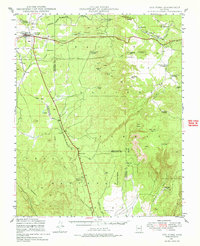
1947 Map of Ash Fork
USGS Topo · Published 1978About this map
The rail-driven settlement of Ash Fork anchors this high-desert landscape on the Coconino Plateau, situated along the critical corridor of the Atchison Topeka & Santa Fe railroad. Mapped just after the war in the late 1940s, the area reveals a complex network of water management essential for livestock and steam rail travel, including the Irishman Dam, Concrete Dams, and numerous tanks like the Big Supai Tank.
Find a feature on this map
55 named features on this map. Tap any name to fly to it.
Don’t see what you’re looking for? This feature index may not catch every label — zoom into the map to look around manually.
Map Details
Editions of this 1947 Ash Fork Map
3 editions found
Other maps of this area

1886 · Chino
USGS Topo · 1:250,000

1887 · Prescott
USGS Topo · 1:250,000

1891 · Chino
USGS Topo · 1:250,000

1892 · Prescott
USGS Topo · 1:250,000

1905 · Jerome
USGS Topo · 1:125,000

1922 · Williams
USGS Topo · 1:125,000

1944 · Clarkdale
USGS Topo · 1:48,000

1947 · Ash Fork
USGS Topo · 1:62,500

1947 · Simmons
USGS Topo · 1:62,500

1947 · Picacho Butte
USGS Topo · 1:62,500