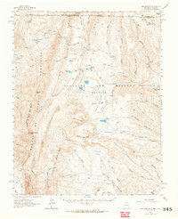
1962 Map of Ash Mountain
USGS Topo · Published 1964About this map
Vermejo Park and the vast Beaubien and Miranda (Maxwell) Grant dominate this 1960s landscape in Colfax County. The high-elevation terrain is defined by the Sangre de Cristo Mountains and a dramatic geologic formation known simply as The Wall. Human presence in this era is marked by scattered outposts and high-country industries, from the Van Lint Mine and Bartlett Mine to family-named sites like Mc Crystal Place and Ring Place. The map provides a look at a transitional period when hunting lodges and work camps like Cressner Lodge and Bremmer Longshed Camp occupied the remote drainages of the Vermejo River and Leandro Creek. Traces of earlier habitation appear at the Penaflor Ruins, while the extensive network of jeep trails reflects the mid-century accessibility of these remote northern New Mexico highlands.
Find a feature on this map
64 named features on this map. Tap any name to fly to it.
Don’t see what you’re looking for? This feature index may not catch every label — zoom into the map to look around manually.
Map Details
Editions of this 1962 Ash Mountain Map
3 editions found

Other maps of this area

1891 · Spanish Peaks
USGS Topo · 1:125,000

1893 · Spanish Peaks
USGS Topo · 1:125,000

1895 · Spanish Peaks
USGS Topo · 1:125,000

1897 · Spanish Peaks
USGS Topo · 1:125,000

1900 · Spanish Peaks
USGS Topo · 1:125,000

1954 · Raton
USGS Topo · 1:250,000

1954 · Trinidad
USGS Topo · 1:250,000

1955 · Cimarron
USGS Topo · 1:62,500

1955 · Ute Park
USGS Topo · 1:62,500

1955 · Trinidad
USGS Topo · 1:250,000