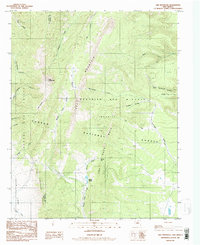
1986 Map of Ash Mountain
USGS Topo · Published 1986About this map
Ash Mountain and the high peaks of the Sangre de Cristo Mountains dominate this 1980s landscape on the border of Taos and Colfax counties. The map details a complex network of canyons and high-altitude water sources, including Shuree Ponds and the headwaters of Middle Poñil Creek. This area, part of the Carson National Forest, reflects a legacy of land grants and conservation, marked by the Grant Boundary and the extensive Beaubien and Miranda (Maxwell) holdings.
Find a feature on this map
28 named features on this map. Tap any name to fly to it.
Don’t see what you’re looking for? This feature index may not catch every label — zoom into the map to look around manually.
Map Details
Editions of this 1986 Ash Mountain Map
This is the sole edition of this map. No revisions or reprints were ever made.
Other maps of this area

1954 · Raton
USGS Topo · 1:250,000

1955 · Ute Park
USGS Topo · 1:62,500

1958 · Raton
USGS Topo · 1:250,000

1962 · Ash Mountain
USGS Topo · 1:62,500

1963 · Red River Pass
USGS Topo · 1:24,000

1963 · Comanche Point
USGS Topo · 1:24,000

1963 · Big Costilla Peak
USGS Topo · 1:24,000

1982 · Wheeler Peak
USGS Topo · 1:100,000
1986 · Vermejo Park
USGS Topo · 1:24,000
1986 · Van Bremmer Park
USGS Topo · 1:24,000