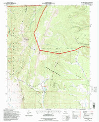
1995 Map of Ash Mountain
USGS Topo · Published 1998About this map
Little Costilla Peak and Ash Mountain dominate this high-altitude landscape within the Sangre De Cristo Grant and the Beaubien and Miranda Grant. The terrain is defined by the expansive Valle Vidal Unit, a region of significant hydrological complexity where headwaters like Middle Ponil Creek, Elk Creek, and Leandro Creek carve through the mountain slopes. Evidence of land use is centered around Shuree, featuring Shuree Ponds and the Shuree Creek drainage, while the historic Mc Crystal Place sits further east along Mc Crystal Creek. This survey captures the transition from traditional land grants to federal forest management, preserving the location of high-country landmarks such as Windy Gap and the open stretches of Elk Meadows.
Find a feature on this map
32 named features on this map. Tap any name to fly to it.
Don’t see what you’re looking for? This feature index may not catch every label — zoom into the map to look around manually.
Map Details
Editions of this 1995 Ash Mountain Map
This is the sole edition of this map. No revisions or reprints were ever made.
Other maps of this area

1954 · Raton
USGS Topo · 1:250,000

1955 · Ute Park
USGS Topo · 1:62,500

1958 · Raton
USGS Topo · 1:250,000

1962 · Ash Mountain
USGS Topo · 1:62,500

1963 · Red River Pass
USGS Topo · 1:24,000

1963 · Comanche Point
USGS Topo · 1:24,000

1963 · Big Costilla Peak
USGS Topo · 1:24,000

1982 · Wheeler Peak
USGS Topo · 1:100,000
1986 · Vermejo Park
USGS Topo · 1:24,000
1986 · Van Bremmer Park
USGS Topo · 1:24,000