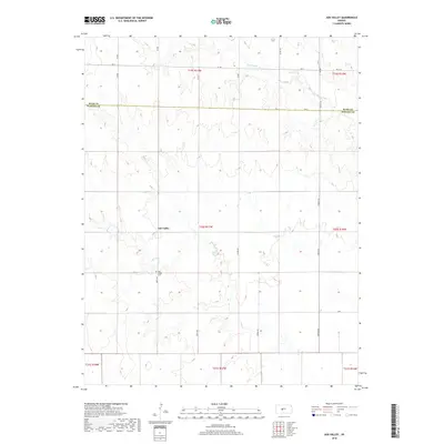
2018 Map of Ash Valley
USGS Topo · Published 2018About this map
Ash Valley serves as the central focal point of this rural landscape, situated within a topography shaped by subtle elevation changes and seasonal watercourses. The northern reaches of the quadrangle are defined by the winding path of Dry Walnut Cr, a drainage that cuts through the agricultural grid. This 2018 survey reveals the persistent section-line road network that governs the movement and property boundaries of this part of Kansas, illustrating how the late-nineteenth-century land system continues to anchor the modern rural environment. The proximity of the Rush County and Pawnee County line further highlights the administrative divisions that have influenced local land use and development for over a century.
Find a feature on this map
2 named features on this map. Tap any name to fly to it.
Don’t see what you’re looking for? This feature index may not catch every label — zoom into the map to look around manually.
Map Details
Editions of this 2018 Ash Valley Map
This is the sole edition of this map. No revisions or reprints were ever made.
Other maps of this area

1889 · Larned
USGS Topo · 1:125,000

1891 · Larned
USGS Topo · 1:125,000

1955 · Great Bend
USGS Topo · 1:250,000

1957 · Great Bend
USGS Topo · 1:250,000

1958 · Great Bend
USGS Topo · 1:250,000
1965 · Albert
USGS Topo · 1:24,000

1966 · Rush Center
USGS Topo · 1:24,000
1966 · Timken
USGS Topo · 1:24,000

1970 · Fort Larned
USGS Topo · 1:24,000
1970 · Sanford
USGS Topo · 1:24,000