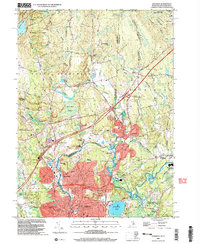
2001 Map of Ashaway
USGS Topo · Published 2003About this map
The Pawcatuck River winds through the borderlands of Rhode Island and Connecticut, anchoring a landscape defined by riverside textile hamlets and early industrial centers. In the southern portion of the sheet, the dense development of Pawcatuck and Stillmanville straddles the state line, where local infrastructure like the Ward High Sch and St Michael Cem serve the growing population. Upriver, the distinct settlements of White Rock and Potter Hill reflect the traditional New England pattern of milling villages established at natural water power sites.
Find a feature on this map
79 named features on this map. Tap any name to fly to it.
Don’t see what you’re looking for? This feature index may not catch every label — zoom into the map to look around manually.
Map Details
Editions of this 2001 Ashaway Map
This is the sole edition of this map. No revisions or reprints were ever made.
Other maps of this area

1889 · Stonington
USGS Topo · 1:62,500

1889 · Charlestown
USGS Topo · 1:62,500

1889 · Moosup
USGS Topo · 1:62,500

1890 · Kent
USGS Topo · 1:62,500

1893 · Moosup
USGS Topo · 1:62,500

1893 · Stonington
USGS Topo · 1:62,500

1894 · Kent
USGS Topo · 1:62,500

1919 · Charlestown
USGS Topo · 1:62,500

1920 · Moosup
USGS Topo · 1:62,500

1921 · Charlestown
USGS Topo · 1:62,500