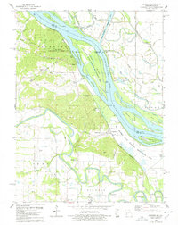
1978 Map of Ashburn
USGS Topo · Published 1978About this map
The Mississippi River and Salt River dominate this riverine landscape at the confluence of several distinct townships including Peno, Saverton, and Buffalo. The late 1970s terrain is characterized by a complex network of backwaters and islands, such as Gilbert Island and Denmark Island, much of which is conserved within the Ted Shanks State Wildlife Management Area. Human activity is concentrated along the Burlington Northern railroad corridor, which links the small settlements of Ashburn and Busch. This map provides significant genealogical value through its high density of family-named cemeteries and burial grounds, including the LaMotte Cem, Robison Cem, and Centenary Cem. The survey also details the extensive river engineering of the era, from the Hadley-Mc Craney Diversion Levee to the Sny Ditch, illustrating how the floodplains were managed for agricultural and recreational use.
Find a feature on this map
64 named features on this map. Tap any name to fly to it.
Don’t see what you’re looking for? This feature index may not catch every label — zoom into the map to look around manually.
Map Details
Editions of this 1978 Ashburn Map
This is the sole edition of this map. No revisions or reprints were ever made.
Other maps of this area

1890 · Louisiana
USGS Topo · 1:125,000

1931 · Barry
USGS Topo · 1:62,500

1932 · Hannibal
USGS Topo · 1:62,500

1936 · Hannibal
USGS Topo · 1:48,000

1936 · Barry
USGS Topo · 1:48,000

1937 · Bowling Green
USGS Topo · 1:62,500

1940 · Bowling Green
USGS Topo · 1:62,500

1943 · Vandalia
USGS Topo · 1:62,500

1944 · Barry
USGS Topo · 1:62,500

1945 · Hannibal
USGS Topo · 1:62,500