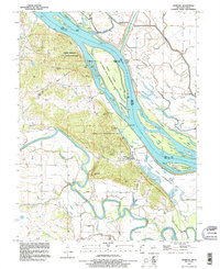
1993 Map of Ashburn
USGS Topo · Published 1995About this map
Ashburn serves as the focal point for this riverside survey, situated where the high bluffs of Ashburn Hill meet the complex wetlands of the Mississippi River. The landscape is dominated by the vast Ted Shanks State Conservation Area, which encompasses Gilbert Island, Denmark Island, and several chutes that define the river's path. Inland, the Salt River and its tributaries like Haw Creek and Sugar Creek carve through the Missouri side of the border, providing a clear view of the hydrological patterns before the modern era of large-scale river engineering.
Find a feature on this map
61 named features on this map. Tap any name to fly to it.
Don’t see what you’re looking for? This feature index may not catch every label — zoom into the map to look around manually.
Map Details
Editions of this 1993 Ashburn Map
This is the sole edition of this map. No revisions or reprints were ever made.
Other maps of this area

1890 · Louisiana
USGS Topo · 1:125,000

1931 · Barry
USGS Topo · 1:62,500

1932 · Hannibal
USGS Topo · 1:62,500

1936 · Hannibal
USGS Topo · 1:48,000

1936 · Barry
USGS Topo · 1:48,000

1937 · Bowling Green
USGS Topo · 1:62,500

1940 · Bowling Green
USGS Topo · 1:62,500

1943 · Vandalia
USGS Topo · 1:62,500

1944 · Barry
USGS Topo · 1:62,500

1945 · Hannibal
USGS Topo · 1:62,500