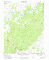
1970 Map of Ashby Gap
USGS Topo · Published 1978About this map
Ashby Gap serves as a critical passage through the Blue Ridge, marking the intersection of Clarke, Loudoun, and Fauquier counties. The landscape is dominated by steep ridges such as Slate Ridge and Piney Ridge, dissected by named hollows like Duke Hollow and Bolden Hollow. Along the Shenandoah River, the topography features dramatic bends including Calmes Neck and river features such as Burwell Island.
Find a feature on this map
50 named features on this map. Tap any name to fly to it.
Don’t see what you’re looking for? This feature index may not catch every label — zoom into the map to look around manually.
Map Details
Editions of this 1970 Ashby Gap Map
4 editions found
Other maps of this area

1884 · Harpers Ferry
USGS Topo · 1:125,000

1891 · Harpers Ferry
USGS Topo · 1:125,000

1893 · Luray
USGS Topo · 1:125,000

1893 · Harpers Ferry
USGS Topo · 1:125,000

1894 · Warrenton
USGS Topo · 1:125,000

1894 · Winchester
USGS Topo · 1:125,000

1905 · Luray
USGS Topo · 1:125,000

1916 · Berryville
USGS Topo · 1:62,500

1938 · Winchester
USGS Topo · 1:48,000

1939 · Front Royal
USGS Topo · 1:48,000