1946 Map of Ashby
USGS Topo · Published 1946About this map
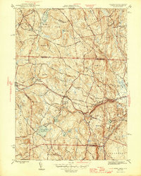
Ashby serves as the focal point of this mid-century survey, which documents the transition from the upland farms of New Hampshire to the developing reservoirs and forests of northern Massachusetts. The landscape is defined by its water resources and elevation, featuring large catchments like the Fitchburg Reservoir and Ashby Reservoir alongside the Souhegan River in the north. The area shows a mature network of local transit, including the Boston and Maine RR serving Mason Sta and a dense web of family-named routes such as Richardson Road and Taylor Road. Within the town center and at South Village, historic burials are marked at Glenwood Cem and South Cem. This era represents a period when the timber and water of the Willard Brook State Forest and Marshall Reservation were increasingly managed as public resources near the borders of Middlesex Co and Worcester Co.
Find a feature on this map
71 named features on this map. Tap any name to fly to it.
Don’t see what you’re looking for? This feature index may not catch every label — zoom into the map to look around manually.
Map Details
Editions of this 1946 Ashby Map
2 editions found

Other maps of this area

1887 · Fitchburg
USGS Topo · 1:62,500

1889 · Fitchburg
USGS Topo · 1:62,500

1893 · Fitchburg
USGS Topo · 1:62,500

1893 · Groton
USGS Topo · 1:62,500

1900 · Peterboro
USGS Topo · 1:62,500

1906 · Milford
USGS Topo · 1:62,500

1931 · Groton
USGS Topo · 1:48,000

1931 · Fitchburg
USGS Topo · 1:48,000

1935 · Groton
USGS Topo · 1:62,500

1935 · Fitchburg
USGS Topo · 1:62,500