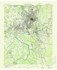
1936 Map of Asheville
USGS Topo · Published 1936About this map
Asheville serves as the hub of this mid-1930s landscape, where the French Broad River and Swannanoa River meet near the Southern RR junction. The map illustrates a city in transition, showing the early suburban development of Biltmore Forest and West Asheville alongside major institutional landmarks like the Biltmore House and Columbia College. Transportation patterns are well-defined by the convergence of U S Highway No 70 and U S Highway No 25, while the surrounding terrain is marked by family-named landmarks and essential community sites, including Eliada Orphans Home and the County Prison. To the south, the Pisghah National Forest begins to take shape, featuring the Bent Creek U S Forest Service Experiment Station. This survey, compiled from aerial photographs by the Tennessee Valley Authority and the Geological Survey, preserves the specific layout of neighborhoods, cemeteries like Violet Hill Cem, and industrial sites before the post-war expansion of the Blue Ridge region.
Find a feature on this map
111 named features on this map. Tap any name to fly to it.
Don’t see what you’re looking for? This feature index may not catch every label — zoom into the map to look around manually.
Map Details
Editions of this 1936 Asheville Map
This is the sole edition of this map. No revisions or reprints were ever made.
Other maps of this area

1894 · Asheville
USGS Topo · 1:125,000

1900 · Mount Mitchell
USGS Topo · 1:125,000

1901 · Asheville
USGS Topo · 1:125,000

1902 · Mount Mitchell
USGS Topo · 1:125,000

1905 · Pisgah
USGS Topo · 1:125,000

1906 · Pisgah
USGS Topo · 1:125,000

1907 · Saluda
USGS Topo · 1:125,000

1935 · Craggy Pinnacle
USGS Topo · 1:24,000

1936 · Enka
USGS Topo · 1:24,000

1936 · Weaverville
USGS Topo · 1:24,000